 Pen Taluka farmers have turned to Google Earth to prove that their lands are fertile. Google Earth is powered by world's superior technology and is one of the largest archives of satellite pictures of the world updated regularly.
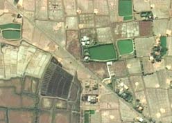
The evil land sharks of Maha Mumbai SEZ along with state government, have marked large tracts of fertile land as salty crek water so that they can acquire the land at throw away prices. Farmers sought the help of Google Earth and produced satellite pictures proving that their lands are fertile.
After a flawed SEZ policy, it's now time to fabricate land records and only god knows what else these hungry land grabbers will do.
No comments:
Post a Comment